Echoes Across the High Salt Flats
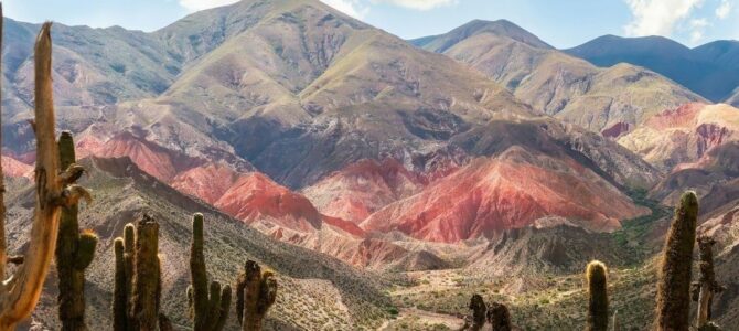
The Argentine Puna is a high, cold and exceptionally dry plateau, generally rising above 3,500 meters and extending across parts of Salta, Jujuy and Catamarca. Its salt flats, volcanic ranges, seasonal streams and scattered wetlands form a landscape that appears austere from a distance but is hydrologically intricate. Water may be concentrated in a spring, held temporarily in a wet meadow, stored underground or distributed through a channel whose value is measured in livestock, crops and household security.
For millennia, Indigenous communities and pastoralists have adapted to this uncertainty. Their systems combine careful observation of seasonal flows, communal rules, small-scale diversion works, grazing decisions and knowledge of soils, springs and wetland vegetation. Archaeological evidence from high-altitude valleys demonstrates that agricultural production and pastoral activity were organized under difficult climatic conditions long before modern infrastructure reached the region.
The current policy challenge is sharper than a simple choice between conservation and development. Lithium, metal mining, renewable-energy infrastructure and scientific projects are expanding in a region where water reserves are difficult to measure and ecological recovery can be slow. The central question is whether industrial growth can operate within basin-scale limits while recognizing Indigenous peoples as rights holders and knowledge partners. Without that integration, the energy transition risks transferring environmental and social costs to communities already managing extreme climatic exposure.
Hydrological Anatomy of the Puna Plateau
Much of the Puna is organized into endorheic, or closed, basins. Water does not flow toward the sea through a continuous river network. Instead, precipitation and groundwater movement terminate in salt flats, lagoons, wetlands or internally draining depressions. High solar radiation, strong winds, low humidity and large temperature fluctuations increase evaporation. Rainfall is scarce and highly seasonal, so a short wet period can determine the ecological and economic conditions of an entire year.
These conditions make groundwater especially important, but groundwater in a salt-flat system is not a single, easily replaceable reservoir. Freshwater recharge may occur in distant mountain zones, move through fractured rock and alluvial deposits, and interact with saline groundwater near the basin floor. The recharge rate of some stores is slow compared with modern pumping requirements. As a result, a project can affect ecosystems beyond the immediate extraction site, particularly where groundwater, springs, streams and wetlands are hydraulically connected.
Bofedales, vegas and related high-altitude wetlands function as natural sponges. Their saturated soils retain water, moderate flow, support native vegetation and provide forage for camelids and other species. They also serve as practical indicators of hydrological change. A declining wetland, altered spring or reduced seasonal flow may reveal a basin-wide problem before a monitoring well provides a clear signal. Conservation frameworks for these fragile endorheic basins draw critical baselines from protected reserves such as the Laguna de los Pozuelos wetland sanctuary.
- Recharge zones in mountain catchments are essential to downstream springs, wetlands and aquifers.
- Wetlands retain water, sustain forage and buffer seasonal variability.
- Salt flats contain complex saline and freshwater interactions that cannot be assessed through surface observations alone.
- Monitoring networks must combine wells, stream gauges, remote sensing, ecological indicators and community observations.
Millennia of Water Stewardship in Quebrada and Puna
Archaeological work in the Quebrada de Morohuasi, in Salta Province, identifies agricultural activity during the Formative Period, between the first and fourth centuries CE, followed by a later phase associated with Inka control in the fifteenth century. Cultivation continued in some of the same areas, but the organization of production and social relationships changed. This record is important for modern planners because it shows that high-altitude agriculture was not an accidental response to favorable weather. It depended on deliberate investment in land, water distribution and social coordination.
Pre-Hispanic terraces, field systems and channels reduced erosion, slowed runoff and made limited water more useful. Such infrastructure did not eliminate climatic risk, but it distributed that risk across cultivated plots, grazing areas and seasonal reserves. The underlying principle remains relevant: in an arid basin, resilience often comes from managing the timing and movement of water rather than simply increasing extraction capacity.
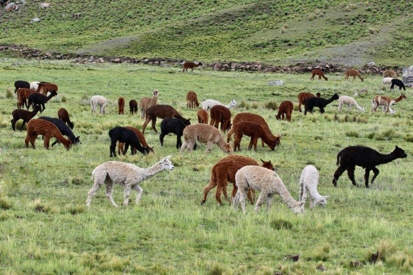
Pastoral management added another layer of flexibility. Llamas provided transport, fiber, meat and manure, while vicuñas occupied a different ecological and management relationship as wild camelids. Herd movements could be synchronized with wetland hydration, forage availability and seasonal water access. Protecting a bofedal was therefore not separate from economic planning. It was a way to protect the productive base of household and community life.
Modern infrastructure can deliver water more quickly and at greater scale, but it can also create new dependencies. Boreholes, pumps and pipelines may expand supply while obscuring aquifer limits, concentrating control or transferring maintenance costs to remote communities. The comparison is not a romantic opposition between ancient and modern systems. It is a practical case for combining durable local rules with reliable engineering, transparent data and maintenance arrangements that remain viable after a project”s initial funding ends.
| System | Primary strength | Key management risk |
|---|---|---|
| Terraces and small diversion channels | Slow runoff, reduce erosion and distribute seasonal water | Damage from neglect, extreme rainfall or poorly planned expansion |
| Bofedales and vegas | Retain moisture and provide forage | Degradation through altered flows, warming and overgrazing |
| Groundwater wells | Provide more predictable access for households and livestock | Over-pumping, salinization and weak monitoring |
| Renewable-energy pumping | Reduces fuel dependence and can support remote services | Extraction may continue beyond sustainable recharge limits |
Industrial Expansion and the Modern Hydro-Social Contract
The global energy transition has increased demand for lithium used in rechargeable batteries. Argentina”s Puna is part of the wider Lithium Triangle, where salt-flat systems in Argentina, Bolivia and Chile have attracted major investment. Salta, Jujuy and Catamarca are consequently under pressure to accelerate exploration, extraction, transport and associated services. The commercial opportunity is substantial, but so is the governance challenge because lithium operations interact with water systems that are highly variable, interconnected and difficult to observe.
Human-rights organizations have documented concerns about access to information, participation, environmental justice and the protection of Indigenous territories in the high Andean salt flats. The issue is not limited to whether a project obtains a formal permit. Communities need understandable information about hydrological models, uncertainty, cumulative impacts and contingency measures before decisions are finalized. Prior consultation and informed participation are therefore central to the legitimacy of the hydro-social contract, not procedural additions after technical design is complete.
Social tension can also arise from impacts that standard environmental assessments do not capture well. Changes in family routines, uncertainty about land access, pressure on local services, health concerns and the unequal distribution of employment can influence whether a project is considered acceptable. Research and public discussion surrounding lithium development in the region have emphasized that consultation must become co-design. A meeting held after a project”s main assumptions are fixed cannot substitute for meaningful influence at the planning stage.
Community-led monitoring offers a workable bridge between local authority and formal regulation. Argentina”s registration of an Indigenous and Community Conserved Territory and Area associated with the Torna Lickana communities in the Salinas Grandes region illustrates how Indigenous governance can make ecological stewardship visible in wider conservation systems. Such arrangements can support monitoring of springs, wetlands, grazing conditions and cultural sites, provided that communities retain control over sensitive knowledge and receive resources for sustained participation.
- Establish basin-wide baselines before expansion, including groundwater levels, water chemistry, wetland extent and ecological condition.
- Publish operational data in accessible formats, with clear explanations of uncertainty and limitations.
- Apply cumulative-impact analysis across mining, agriculture, households and climate variability rather than assessing projects in isolation.
- Recognize Indigenous monitoring as evidence that can complement, challenge and improve conventional technical studies.
- Define enforceable thresholds for withdrawal, wetland decline, salinization and corrective action.
Frameworks for Integrated High-Altitude Development
Effective governance must operate across provincial boundaries because hydrological systems do not follow administrative lines. Salta, Jujuy and Catamarca face similar pressures but have different institutions, permitting practices and development priorities. Regional coordination can improve data compatibility, emergency planning, environmental assessment and negotiation with project operators. Coordinated governance models have gained momentum through initiatives such as the regional collaboration platform for the Puna, which demonstrates the value of joint approaches to landscape stewardship and development.
For smallholders and remote settlements, renewable-energy water systems can be useful when paired with ancestral diversion and storage techniques. Photovoltaic pumps, wind systems and small hybrid installations have been tested as alternatives for supplying irrigation, livestock and household needs in the Jujuy Puna. Their success depends on more than equipment. Designs must address water quality, spare parts, local technicians, ownership, operating rules and the risk that inexpensive pumping encourages unsustainable withdrawals.
Local economic development should also include technical and educational pathways that keep skilled residents connected to their territories. Training in hydrological sampling, solar installation, equipment maintenance, geographic information systems, hospitality and environmental compliance can create opportunities beyond low-skilled service roles. Programs such as certified local training initiatives in the Salta Puna point toward a broader model in which universities, companies, public agencies and communities build a workforce capable of participating in both conservation and industrial decision-making.
- Create shared regional baselines. Align monitoring methods and publish comparable data across Salta, Jujuy and Catamarca.
- Combine technologies with local practice. Pair renewable pumps and digital sensors with community water rules, traditional channels and wetland management.
- Make participation operational. Fund community monitoring, independent technical review and accessible consultation before project design is locked in.
- Build territorial skills. Develop accredited training that connects young residents with environmental science, infrastructure maintenance and responsible industry.
- Use adaptive permits. Require projects to respond to measured hydrological and ecological change rather than relying on one-time approval.
Building Climate Resilience Through Ancestral Blueprints
The Puna”s ancient water systems offer a practical lesson for modern arid-region engineering. Resilience comes from slowing flows, protecting recharge areas, maintaining wetlands, spreading risk and matching use to seasonal availability. Contemporary science can improve these systems through isotope studies, remote sensing, groundwater models, ecological indicators and transparent data platforms. Yet technical sophistication is not a substitute for local observation. The most reliable planning combines both forms of knowledge.
Indigenous communities should therefore be treated as primary knowledge partners, rights holders and decision-makers, not peripheral stakeholders invited to validate plans already developed elsewhere. Their experience covers hydrological change over generations, pasture condition, spring behavior, animal movement and the cultural significance of particular landscapes. Partnership requires compensation, access to information, protection of confidential knowledge and a genuine ability to alter or reject proposals where rights and ecological limits are at stake.
For companies, researchers and policymakers, the actionable pathway is clear. Begin with basin-scale science and community-defined priorities; disclose uncertainty rather than hiding it behind precise-looking forecasts; monitor freshwater and wetlands throughout the project life cycle; establish enforceable thresholds and remedies; and invest in local technical capacity. Industrial expansion may contribute to Argentina”s economic and energy-transition goals, but its long-term credibility will depend on whether the Puna”s water systems, communities and ecological memory remain intact.